Yesterday, I logged onto the FCC ULS website to see if there was an update to the application I submitted on the 10th. I was pleased to see that I now have a callsign and MMSI issued for Rhapsody. It only took 4 days. This is good news in case someone is coming up on a long voyage and needs it quickly.
Since I don't need AIS or DSC functions right now, I have plenty of time to research equipment and add it during the refit period or as funds come available.
Showing posts with label GPS. Show all posts
Showing posts with label GPS. Show all posts
Saturday, August 17, 2013

Saturday, August 10, 2013
How do you get an MMSI from the FCC?
This question is asked by many by those who want to get a DCS capable radio or to be able to transmit AIS position reporting. Some day, I'd like to add both of these capabilities and need to get an MMSI ahead of time.
From my limited research, you file for your MMSI from the FCC if your vessel will be traveling to international waters and foreign countries, even if it's to Canada or Bahamas and beyond. If your vessel is going to be in US waters only, you can apply through BoatUS.
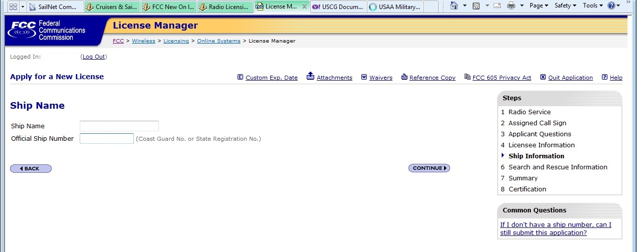
I was looking at the process of how to do this and found a forum post where someone talked about it in a post from 2007. To get started, you need to get on the FCC Universal License System (ULS) website. If you don't already have an FCC Registration Number (FRN), you need to register for one. Being an amateur radio operator, I already had one so I just had to log in and submit a new application in order to get an MMSI.
There's a lot of pictures here, but follow this process with the information needed for yourself and your vessel and you should be good. I'm no expert here but this will give you an idea of what to expect during the process. I just did this process and it didn't take long to do at all. The longest part of this was making the screen shots to share with everyone else. Good luck!
NOTE: The cost for this application is $160.


From my limited research, you file for your MMSI from the FCC if your vessel will be traveling to international waters and foreign countries, even if it's to Canada or Bahamas and beyond. If your vessel is going to be in US waters only, you can apply through BoatUS.
I was looking at the process of how to do this and found a forum post where someone talked about it in a post from 2007. To get started, you need to get on the FCC Universal License System (ULS) website. If you don't already have an FCC Registration Number (FRN), you need to register for one. Being an amateur radio operator, I already had one so I just had to log in and submit a new application in order to get an MMSI.
There's a lot of pictures here, but follow this process with the information needed for yourself and your vessel and you should be good. I'm no expert here but this will give you an idea of what to expect during the process. I just did this process and it didn't take long to do at all. The longest part of this was making the screen shots to share with everyone else. Good luck!
NOTE: The cost for this application is $160.




Monday, January 21, 2013
REFIT Plan: Instruments
This part of my refit plan, I'm looking at replacing the Garmin 546s and Furuno radar. Lately, the Furuno stopped working which I may just need to trace the power to see if I can get it working again. While the 546s still works, I like the idea of having a bit larger screen.

Both of these are mounted by the electrical panel on a swing out arm to be viewable in the cockpit. Both take up quite a bit of space and I'm thinking it would be nice to consolidate the two into one system.
My idea for the upgrade is to get a Garmin 4208 chartplotter with a Garmin Radar, either the 18HD or 24HD. The Garmin 740s also seems to be popular and is touchscreen and costs less. Currently, the Furuno radar antenna is mounted on a pole on the stern rail. I'm thinking to mount it a little higher with a Scanstrut mount on the mast.
I can mount this single screen on the swing mount but I'm leaning more towards the idea of placing it where the bulkhead compass is currently mounted. This way, I won't have to have it swing back and forth on the swing mount. I'll look into how it might work out later but this is my current plan.
If this new chartplotter is mounted in place of the compass, I thinking to make a new companion way panel that is low profile, but big enough to mount the compass. This panel would removable for the times when not sailing.
Garmin also has AIS capabilities that can be viewed on the chartplotter. This is something I considered adding to this installation but I may not use AIS (yet). Maybe a VHF radio with AIS receiver could be a good alternative. Another aspect of some of the equipment is the possibility of using it outside of the US. That's when the FCC comes in where a Ship Radio Station license and Restricted Radiotelephone Operator Permit seems to be needed. Just something else to research along the way.

Both of these are mounted by the electrical panel on a swing out arm to be viewable in the cockpit. Both take up quite a bit of space and I'm thinking it would be nice to consolidate the two into one system.
My idea for the upgrade is to get a Garmin 4208 chartplotter with a Garmin Radar, either the 18HD or 24HD. The Garmin 740s also seems to be popular and is touchscreen and costs less. Currently, the Furuno radar antenna is mounted on a pole on the stern rail. I'm thinking to mount it a little higher with a Scanstrut mount on the mast.
I can mount this single screen on the swing mount but I'm leaning more towards the idea of placing it where the bulkhead compass is currently mounted. This way, I won't have to have it swing back and forth on the swing mount. I'll look into how it might work out later but this is my current plan.
If this new chartplotter is mounted in place of the compass, I thinking to make a new companion way panel that is low profile, but big enough to mount the compass. This panel would removable for the times when not sailing.
Garmin also has AIS capabilities that can be viewed on the chartplotter. This is something I considered adding to this installation but I may not use AIS (yet). Maybe a VHF radio with AIS receiver could be a good alternative. Another aspect of some of the equipment is the possibility of using it outside of the US. That's when the FCC comes in where a Ship Radio Station license and Restricted Radiotelephone Operator Permit seems to be needed. Just something else to research along the way.
Thursday, June 7, 2012
GPS Software Update
I went to Rhapsody for a few minutes today. I have a Garmin 546s Marine GPS. The system software on the unit was version 3.10 and the most recent version is 4.20. I found that the GPS had software from 9 versions ago. I used an SD card from my camera and used it to update it. It took a few times and took my laptop and used it to load the SD card a couple times and repeating until it worked.
I also recently bought some maps for the GPS. I bought Garmin Vision lake maps for Southeast US from GPScity.com that seems to have better prices than others I found. It seemed to work well with the GPS. It also has some basic maps for land. I'm looking forward to getting Rhapsody in the water to test it out.
I also recently bought some maps for the GPS. I bought Garmin Vision lake maps for Southeast US from GPScity.com that seems to have better prices than others I found. It seemed to work well with the GPS. It also has some basic maps for land. I'm looking forward to getting Rhapsody in the water to test it out.
Subscribe to:
Posts (Atom)